Locals alarmed at strange geological event near Kudankulam
06-June-2012
Vol 3 | Issue 22
On 3-6-2012, Sunday, a strange geological event occurred at Manappad, located about 44 Km North East of the Kudankulam Nuclear Power Project (KKNPP) site. The event was witnessed by the local people. The event raises many disturbing questions with respect to the safety of the reactors being built hastily at the site.
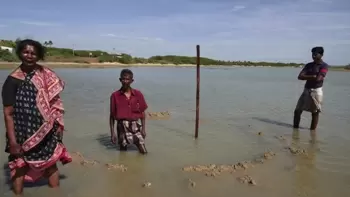
At about 6.10 am Flone Gomez (60), a fisher woman, heard a very loud blast outside her house. Her house is situated on the southern bank of the Karumaniyar backwaters, at about 700 meters south east of the Manappad Karumaniyar Bridge.
 |
|
Flone (in picture) saw the fountain at the spot marked by arrow
|
The sound was so loud that all the members of her house and her neighbors ran out to see what was happening. What they saw baffled and frightened them.
The Karumaniyar is about 1000 meters wide in front of Flone’s house. It does not have fresh water and is filled with the sea water. Usually in May the river is dry but this year the sea continues to fill it. The low tide occurs at about 9 am and the water level rises after 11 am. Fisherfolk catch crabs in this creek when they do not venture into the sea.
At about the center point of the river in front of Flone’s house “the water had raised into a fountain reaching the height of the street lamp post. The diameter of this fountain was about 10 to 12 feet. It looked like a circular well water rising up.
“The fountain lasted for about 1 1/2 to 2 minutes. Then the water fell back to its original state. The water in the circle was then seen boiling with bubbles coming up, for the next 2 minutes.
“Then something from the bottom – mud or rocky material circular in shape - started rising up like a pancake. It rose to about 2 feet above the water level and this lasted for about 1 minute. Then it fell down and the whole event was over.
“The spot has well marked circular boundary even today and is about 4 feet deep while the spots around it are only 1-2 feet deep.
“The event was reported to the local Panchayat chief who in turn alerted the Police. The Police came to the spot at about 10 am and made the initial enquiry. No one from KKNPP or the Geology Departments (both Central and the State) has visited the spot yet.”
Flone was disturbed to see a few newspapers reporting the event as possibly due to a bomb blast. She questioned “If it was due to a bomb, then there was no smoke, no smell and how can it produce a water fountain of the height of a lamp post? How can you explain the water boiling after the water sprout had subsided? How can one explain the circular pancake like mud rising after this? It definitely cannot be due to a bomb.”
When Professor Victor Rajamanickam, an eminent senior Geologist who had conducted many geo chemical and geo morphological studies in this area was contacted, he opined: “This seems to be like a geo-thermal event; something like a hot water spring. The spot (8.381N, 78.05E) is located on the Achankovil shear zone.
“Hence one should think whether this shear zone is currently becoming active. The rock melt extrusions that had occurred at Abhishekappatty, Thiruppanikarisalkulam, Anikulam and Surandai in the years 1998, 1999 and 2001 had in fact alerted us to this point.
Now, this event, alerts us to this issue once again. The Department of Atomic Energy (DAE) should look into this at once and appoint a panel of geologists to study this event geologically, geo chemically and geo physically, so that the safety of the reactors will not be jeopardized.”
In fact, the DAE had neglected such events in the past. It chose to send its geologists to look at the Rock Melt Extrusion sites after a period of 13 years (in January 2012) only after People’s Movement Against Nuclear Energy (PMANE) had presented clinching scientific evidences about their volcanic origin. But even before analyzing the samples they had collected, they chose to conclude that the rock melt was indeed due to leakage from the high tension electricity lines.
 |
|
The spot where the fountain was sighted has a depth of 4 feet while surrounding areas are only 1-2 feet deep
|
The geo thermal event at Manappad in fact confirms the idea put forward by Biju John, D.T. Rao, Yogendra Singh and others in their paper titled “Neotectonic Signatures in the southern Peninsular India and Gulf of Mannar” that the Achankovil shear is becoming active in recent times.
It would be helpful if one remembers that it is these three scientists from the Institute of Rock Mechanics, Kolar who were given the job to study the Rock Melt Extrusion sites by the DAE in January 2012 and it is an irony that they are yet to release the results of their January 2012 studies on the Rock Melt Extrusions.
A similar event had happened at Pannayarkulam, located 11 km north of the KKNPP site in November 2011 during the monsoon rains. This event in which the land had subsided suddenly into a deep pit that was rapidly sucking the water flowing from the nearby area had indicated that this might be a sill hole in a Karst terrain. The expert teams appointed by the Government of India and Tamil Nadu chose to ignore the facts that PMANE presented regarding this event.
The present event at Manappad and the high subsurface heat flow found at Nagarkovil from 1991 suggests that the Achankovil shear zone and the region south of it should be studied in depth for their geo thermal nature. This indeed becomes very important when nuclear reactors are being constructed in the region.
Hence, commissioning of the reactors should be stopped immediately. The Manappad hot water sprout should be studied thoroughly and only after placing the results of this study in the public, should further decisions be taken on the reactors. - (Courtesy: People’s Movement Against Nuclear Energy)


